Predict, Prepare, Prevail-
with CoS-IT-FLoWS

Open-source Community Sourced, Impact-Based Flood Forecast and Early Warning System

Open-source Community Sourced, Impact-Based Flood Forecast and Early Warning System

Request Demo

Request Demo

Request Demo

Request Demo

Overview

Overview

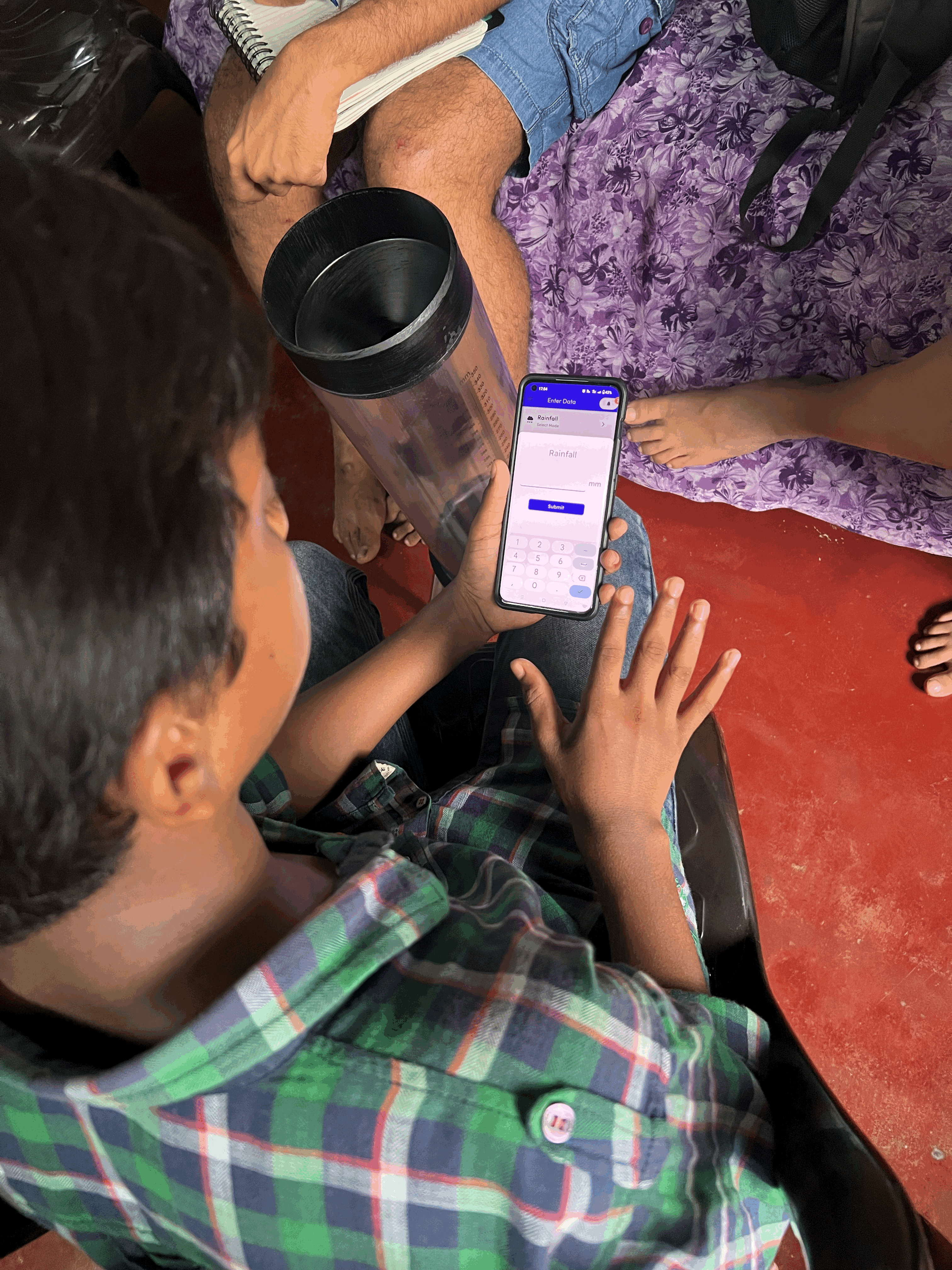
The system integrates real-time and hyper-local community data with flood forecasting models and predictive analytics.

Impact-based to support emergency decisions for disaster management agencies and communities.

Community

Gauge

Gather

Insight Dashboard

Community

At the heart of CoS-IT-FLoWS are local communities, whose observations provide critical data for real-time flood monitoring and impact assessment.

Gauge

Easy to use, low-cost water-level monitoring systems placed in key locations help standardize community observations into actionable data.

Gather App

A user-friendly mobile app allows data gatherers to report water levels, and local flood incidents, bridging ground realities.

Insight Gather Dashboard

Collected data is processed and visualised on an interactive dashboard, enabling stakeholders  to generate tailored forecasts and warnings.

The History

2018
2018
2018

Kerala Floods

Kerala Floods

Impact assessment of Chalakudy and Periyar river basins

2018-19
2018-19
2018-19

Pilot Study

Pilot Study

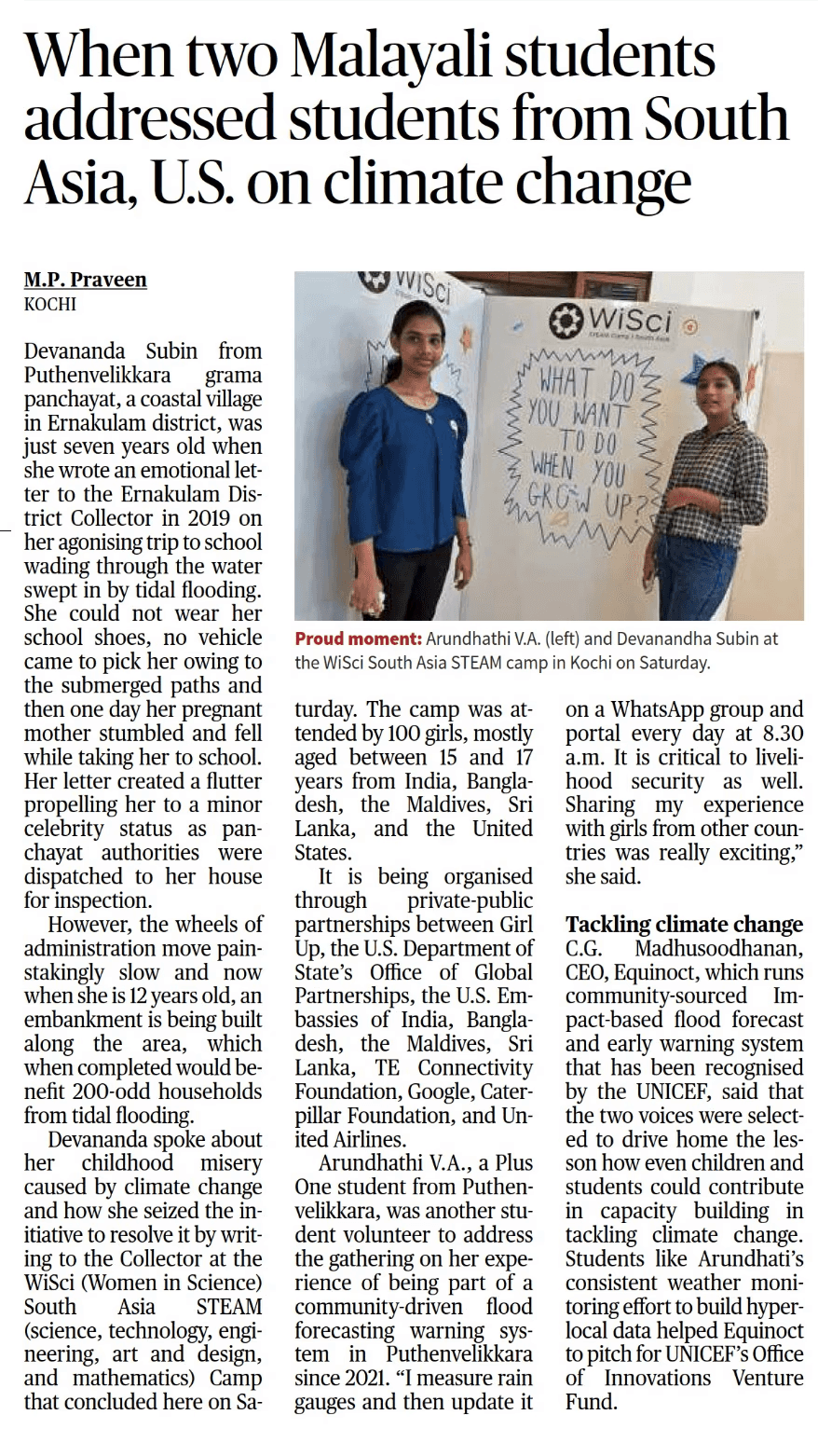
Community-led damage assessment survey in Puthenvelikkara village.

2020
2020
2020

Community Monitoring

Community Monitoring

Launched community rainfall and water monitoring systems

2021
2021
2021

Digital Initiative

Digital Initiative

Launched community rainfall and water monitoring systems

2022
2022
2022

Partnerships

Partnerships

Flood inundation mapping initiative with regional engineering colleges.

2023-24
2023-24
2023-24

UNICEF Climate Action Cohort

UNICEF Climate Action Cohort

Piloting CoS-IT-FLOWS forecasting.

Components

Community

Community

Community

Flood-prone communities have long relied on traditional knowledge and lived experiences to predict and navigate floods. However, these insights were often fragmented, undocumented, and overlooked in conventional forecasting systems. Limited access to reliable early warnings and real-time data left residents vulnerable, forcing them to make critical decisions with incomplete information.

Flood-prone communities have long relied on traditional knowledge and lived experiences to predict and navigate floods. However, these insights were often fragmented, undocumented, and overlooked in conventional forecasting systems. Limited access to reliable early warnings and real-time data left residents vulnerable, forcing them to make critical decisions with incomplete information.

Flood-prone communities have long relied on traditional knowledge and lived experiences to predict and navigate floods. However, these insights were often fragmented, undocumented, and overlooked in conventional forecasting systems. Limited access to reliable early warnings and real-time data left residents vulnerable, forcing them to make critical decisions with incomplete information.


How Does Community Involvement Make our Solution Effective?


How Does Community Involvement Make our Solution Effective?


How Does Community Involvement Make our Solution Effective?

CoS-IT-FLoWS is developed on the premise that those who experience flooding firsthand hold invaluable knowledge. By integrating their real-time observations with scientific tools, we create more accurate, localized flood forecasts.


Community engagement ensures that flood warnings are not just data-driven but also practical, actionable, and trusted by the people they serve.

Gauge

Gauge

Gauge

Every gauge is deployed with the involvement of local communities, ensuring strategic placement in high-risk areas. These gauges serve as both data collection tools and awareness-building instruments.

Every gauge is deployed with the involvement of local communities, ensuring strategic placement in high-risk areas. These gauges serve as both data collection tools and awareness-building instruments.

Every gauge is deployed with the involvement of local communities, ensuring strategic placement in high-risk areas. These gauges serve as both data collection tools and awareness-building instruments.

User friendly & Low-cost

User friendly & Low-cost

User friendly & Low-cost

With durable water level indicators for easy community reporting.

With durable water level indicators for easy community reporting.

With durable water level indicators for easy community reporting.

Color-coded markers

Color-coded markers

Color-coded markers

To align with flood risk levels.

To align with flood risk levels.

To align with flood risk levels.

QR codes

QR codes

QR codes

Linking to live updates and emergency contacts.

Linking to live updates and emergency contacts.

Linking to live updates and emergency contacts.

To maximize engagement, we conduct river journeys,  hands-on training sessions, equipping residents with the knowledge to use, maintain, and interpret the gauges effectively.

Gather App

Gather App

Gather App

The Gather App refines - data gathering and communication process by providing a dedicated, structured platform for real-time monitoring, flood reporting and alerts.

The Gather App refines - data gathering and communication process by providing a dedicated, structured platform for real-time monitoring, flood reporting and alerts.

The Gather App refines - data gathering and communication process by providing a dedicated, structured platform for real-time monitoring, flood reporting and alerts.

Data Entry Field

Data Entry Field

Data Entry Field

Quick and easy water level and rainfall reporting.

Quick and easy water level and rainfall reporting.

Quick and easy water level and rainfall reporting.

Hazard Reporting

Hazard Reporting

Hazard Reporting

Real-time logging of localized flood impacts.

Real-time logging of localized flood impacts.

Real-time logging of localized flood impacts.

History Log (Upcoming)

History Log (Upcoming)

History Log (Upcoming)

Track past flood data for improved forecasting.

Track past flood data for improved forecasting.

Track past flood data for improved forecasting.

Interested in becoming a Gather Volunteer?

Sign Up Here!

Insight Gather Dashboard

Insight Gather Dashboard

Insight Gather Dashboard

The dashboard transforms community-sourced data into actionable  flood forecasts and impact visualisations. It provides a centralized platform for monitoring, forecasting, and decision-making—bridging the gap between on-the-ground realities and early action.

The dashboard transforms community-sourced data into actionable  flood forecasts and impact visualisations. It provides a centralized platform for monitoring, forecasting, and decision-making—bridging the gap between on-the-ground realities and early action.

The dashboard transforms community-sourced data into actionable  flood forecasts and impact visualisations. It provides a centralized platform for monitoring, forecasting, and decision-making—bridging the gap between on-the-ground realities and early action.

Monitor

Monitor

Monitor

Visualize real-time flood monitoring and reports from community members.

Visualize real-time flood monitoring and reports from community members.

Visualize real-time flood monitoring and reports from community members.

Forecast

Forecast

Forecast

Generate impact-based flood forecasts for proactive action.

Generate impact-based flood forecasts for proactive action.

Generate impact-based flood forecasts for proactive action.

Customisation

Customisation

Customisation

Tailor alerts and insights based on geographic location, flood history, and vulnerability levels.

Tailor alerts and insights based on geographic location, flood history, and vulnerability levels.

Tailor alerts and insights based on geographic location, flood history, and vulnerability levels.

Collaborators

Collaborators

Features

Inclusive & Participatory Design

Ensures accessibility and engagement for all community members.

Open-Source Technology

Enhances transparency, collaboration, and adaptability for broader accessibility and innovation.

Integrated Product Design

Combines hardware, software, and local knowledge for a seamless system.

Connecting Diverse Stakeholders

Brings together communities, scientists, government and policymakers.

Digital Inclusion for Everyone

Prioritizes access through low-tech, mobile-first solutions.

Hyper-Local Climate Action

Data collection is tailored to each region’s specific challenges.

Our Impact

CoS-IT-FLoWS is more than a forecasting system—
it’s a collaborative, community-driven climate resilience model.

CoS-IT-FLoWS is more than a forecasting system—
it’s a collaborative, community-driven climate resilience model.

CoS-IT-FLoWS is more than a forecasting system—
it’s a collaborative, community-driven climate resilience model.

  • 150+

    Data Gatherers

  • 3,200

    Collaborative projects

  • 9,600

    Active contributors

  • 150+

    Data Gatherers

  • 3,200

    Collaborative projects

  • 9,600

    Active contributors

Scaling the Solution

CoS-IT-FLoWS is scaling its implementation while continuously refining operational, social, and financial sustainability.

Global Adaptation Potential

  • Scalable worldwide:
    CoS-IT-FLoWS adapts to any flood-prone region globally, leveraging local community networks and open-source technology.

  • Hybrid Business Model: Freemium for communities. Premium features for businesses and government agencies. Includes custom impact assessments with sector-specific forecasting.


  • Expanding to toxic gas leakage monitoring, fire hazards, and emergency response systems.

Strategic Deployment

  • Deploying climate dashboards at District Emergency Operations Centres, Panchayat offices, and industrial hubs like BPCL Kochi Refinery and Cochin International Airport.

  • Strengthening collaborations with the Kerala Startup mission(KSUM), Kerala State Disaster Management Authority (KSDMA), Central Water Commission (CWC), National Disaster Management Authority (NDMA), and global partners.

Research

Link 1

Link 1

Link 1

Link 2

Link 2

Link 2

Link 3

Link 3

Link 3

CoS-IT-FLoWS is grounded in extensive research on community-driven flood forecasting, impact-based modeling, and early warning systems. Studies show that integrating hyper-local observations with scientific models significantly enhances forecast accuracy and response effectiveness.

CoS-IT-FLoWS is grounded in extensive research on community-driven flood forecasting, impact-based modeling, and early warning systems. Studies show that integrating hyper-local observations with scientific models significantly enhances forecast accuracy and response effectiveness.

CoS-IT-FLoWS is grounded in extensive research on community-driven flood forecasting, impact-based modeling, and early warning systems. Studies show that integrating hyper-local observations with scientific models significantly enhances forecast accuracy and response effectiveness.

© EQUINOCT. 2025

Instagram

Email